| Dolpo is a Tibetan-like
region lying to the north, and in the rain-shadow of
the main Himalayan 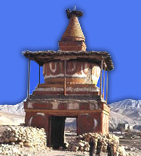
peaks. Like nearby Mustang, it has a unique culture.
Its people wear traditional Tibetan-style
clothes and jewellery and practise the pre-Buddhist
animistic religion of Bon Po. Its remoteness and the
fact that only until recently it was strictly off-limits,
has meant that the traditions and way of life have remained
intact.
In the autumn of 1990 we were the first British tour
operator to organise a trek from east to west, from
Pokhara to Jumla through Lower Dolpo. This route, newly
opened by the Nepalese authorities, hiked into the western
end of Nepal where few Europeans have travelled. It
passed many gigantic mountain ranges - Annapurna, Dhaulagiri
and Kanjiroba, to name but a few - and passed through
Lower Dolpo, at one time a small kingdom in its own
right.
More recently we have repeated the route, with variations
and our groups see very few other
Europeans and enthused greatly about the wild remoteness,
the stunning mountain scenery and the fact that the
local people had that innocent friendliness peculiar
to people who live in excessively remote mountainous
regions.
In the past few years, building on our knowledge, we
have explored some of the most isolated villages of
Upper Dolpo, and we will re-visit them again this year.
In 1997 we were, to our knowledge, the first British
company to cross the Kang La to visit Shey Gompa and
Saldang. Most villages in Dolpo are removed from the
rest of the world to the south by one or more difficult
passes. The people that live here number only a few
hundred and are among the world's highest dwellers.
The villages in Upper Dolpo are 14,000ft/4,300m and
above. It is here specifically that people still practise
the pre-Buddhist Bon Po religion. This early sect was
almost entirely replaced after Buddhist doctrine began
to spread across Tibet in the 9th century. Dolpo remained
unknown to the rest of the world until David Snelgrove
discovered the region in 1956. His account of his seven-month
journey in the inner mountain areas of west and central
Nepal, titled 'Himalayan Pilgrimage' is the most authoritative
work describing this region. The best known book though,
is the evocative and romantic novel by Peter Matthiessen
- 'The Snow Leopard'.
| Fact Box |
|
| Starting
from: |
Kathmandu. Nepalgunj
by bus. |
| Ending
at: |
Flight/Juphal/Nepalgunj/Kathmandu. |
| Grade: |
Moderate-Difficult
|
| Highest
access of the trek: |
Kangla pass ( 5400m) |
| Culture
encounter |
Gurung, Tamang |
| Trekking
type |
Camping |
| Himalayan
sights: |
Dhaulagiri, Fishtail,
Annapurna range, Manaslu, Nilgiri etc |
| Most
Attraction of the trek: |
Landscape, phokshendu
lake, water fall, monestary, blue sheep |
| Best Seasion: |
February, March, April, May,
October, November |
| Meal: |
breakfast, lunch, & Dinner) |
| Activities:
|
Trekking |
| Transportation:
|
Car / Van |
| Accommodation: |
Camping |
| Minimum
Group Size: |
1 |
| Per
day Walking: |
5 to 7 hours |
| Itinerary type |
Fixed / Customized |
| Day to Day Itinerary |
| Day
01 |
Arrive
in Kathmandu Airport & Transfer to Hotel
Welcome dinner in the evening. |
| Day
02 |
Full
day Sightseeing in Kathmandu Valley.
We will be visiting three of the famous heritage
sites in Kathmandu. You will visit first the Swayambunath
Stupa (Monkey Temple). It is said that
Swayambunath Stupa is more than 2,000 years old,
and it symbolizes knowledge. The painted eyes on
all four sides symbolize the all-seeing power of
Buddha. It is an important Buddhist place where
pilgrims from all over the world come.
It
is a 30 minutes drive to Boudhanath
Stupa, another important Buddhist pilgrims
site. This ancient Stupa is considered one of the
biggest in the World. Every morning and evening,
many Buddhist devotees come here to pray and circumambulate
enabling the visitors to observe local religious
practices.
One
of the holiest hindu shrines in the world,
The fabulous pagoda houses the linga of
Lord Shiva and people bathe in the Bagmati River
with a faith of cleansing themselves spiritually.
Many Sadhus or Hindu Ascetics live here. During
religious festivals, Hindus come to make offerings,
and it is sometimes very crowded.
Bhaktapur
Durbar Square: This former royal palace
complex offers the elegant 15th century Palace of
55 win-dows, artistic courtyards, the Golden gat.
Patan
Durbar Square : Durbar Square an enchanting
melage of palace buildings, courtyards and pagoda
temples, is the center of Patan's religious and
social life. |
| Day
03 |
FLY
TO NEPALGANJ. 1 hour flight.
The morning will be free to carry on souvenir hunting
or sightseeing, and in the afternoon you will take
the flight to Nepalganj. The flight will give good
views of the Himalaya to the north. Transfer to
the your hotel. There will be time in the evening
to have a look around the town which is situated
3 kms from the southern Nepalese border with India.
Here it is quite hot and tropical. Overnight Hotel |
| Day
04 |
FLY
TO JUPHAL, (7,872ft/2,400m) THEN TREK TO DUNAI
(7,052ft/2,150m). 2-3 hours. It is an beautiful
walk through ridge of hill and passing many villages
along the way.
A wonderful early morning, 45-minute flight over
the Himalayan foothills, with the major peaks including
Annapurna and Dhaulagiri to the north east. After
an exciting landing at the mountain airstrip at
Jophal you meet your trek crew and Sherpa sirdar.
It takes about an hour to descend through the village
below the airstrip. You then walk through terraced
fields to the Bheri River and the narrow gorge leading,
in 2 hours, to Dunai. This is a much larger village
or small township and is the administrative headquarters
of the Dolpo region. Camp overnight. |
| Day
05 |
TREK
TO ANKHE. (8,724ft/2,660m). 6-7 hrs.
From the King Mahendra statue in Dunai
you cross the new suspension bridge and turn west,
following the trail past the new hospital. At the
confluence of the Thuri Bheri and Suli Gad rivers
you turn to the north and follow the Suli Gad. The
trail is fairly undulating but mostly up and the
going is firm underfoot. You are never far from
the river and can always hear its roar. You pass
through an area which is overgrown with marihuana
plants but also has crops for the villagers and
animals including millet, pumpkin, potatoes, sweet
corn and chillies. Many of the villages in this
area are involved in the production of a lotus-like
plant called 'chuk' that is used to make vinegar
and medicines. It is dried and flown from Dolpo
to Nepalganj and exported to India. You continue
to track the river and eventually reach the settlement
of Hanke, which is also the entrance to the Phoksundo
National Park. The three villages you pass through
have a strange name connection: Parela, meaning
eyelash, Rahagaon meaning eyebrow, and Ankhe meaning
eye. Camp overnight. |
| Day
06 |
TREK
TO RENJE. (10,184ft/3,104m). 7 hrs.
The trail undulates to start with but once you have
crossed the river twice on well made bridges, you
then make a steep ascent on a very narrow path hugging
the cliff face. Having descended to the river again
the trail takes another steep ascent necessitating
frequent stops to admire the scenery, for water
and for breathers. Your night stop is located on
the opposite side of the Suli Gad River from the
village of Renje. Camp overnight. |
| Day
07 |
TREK
TO PHOKSUNDO LAKE. (Approx. 11,808ft/3,600m). 6-7
hrs.
You continue to track the river and the going is
fairly easy initially. A stop at the National Park
Office near Sumdo is well worth a visit. From Sumdo
the trail is very severely up. Here you leave the
river and follow the path high above the water.
You ascend to a ridge, about 12,710ft/3,875m, from
where you will have the most staggering views of
a 1,000ft/300m waterfall, the highest in Nepal,
and your first view of Phoksundo Lake, a study in
turquoise. You then descend through birch
forests to the upper reaches of the Phoksundo Khola
and on to the picturesque settlement of Ringmo with
its mud plastered chortens and mani walls. The village
now has solar panels helping to improve the quality
of life of the villagers. From the settlement it
is a short walk to the shores of Phoksundo Lake
where you set up camp. |
| Day
08 |
REST
DAY.
The nearby Tibetan Buddhist monastery is
well worth a visit, as is the village of Ringmo.
A walk part way round the lake is also very relaxing.
Time also to catch up with domestic chores. Camp
overnight. |
| Day
09 |
TREK
TO PHOKSUNDO KHOLA. (11,575ft/3,507m). 5-6 hrs.
From the lakeside you follow the trail
that skirts the edge of the lake itself. This precarious
trail is suspended on a gangway of wood supported
on pegs driven into crevices in the rocks and signals
the remoteness of the area you are about to enter.
You go very steeply up, to 13,251ft/4,040m, and
then plunge down again to the valley bottom to enter
the flood plain of the Phoksundo Khola and trek
to your night stop alongside the river, but within
the confines of the forest to avoid the worst of
the wind which is prevalent in the valley bottom.
Camp overnight. |
| Day
10 |
TREK
TO PHOKSUNDO BHANJYANG. (14,528ft/4,402m) 7-8 hrs.
There are quite a few stream crossings
today, so you should take sandals or footwear suitable
for knee deep crossings.
This morning you continue along the level
path through a glacial valley that now heads due
north. As this becomes narrower and narrower there
are impressive vertical cliffs and contorted rock
formations. At the confluence of the Phoksundo Khola
and another, unnamed, mountain stream there is an
old wooden bridge. Here you take the barely discernible
path to the north east up a side valley which has
a cavernous look. There is no trail as such, so
it is necessary to clamber over rocks and boulders
and to ford a stream that rushes down the steep
valley. A long climb brings you to a sheep meadow
where the trail veers up a steep ravine. A hard
climb to the top brings you to
yet another valley where you can see the Kang La,
the pass will lead you to Shey Gompa. You camp just
before the pass in a place that Peter Matthiessen
christened 'Snowfields Camp'. |
| Day
11 |
CROSS
THE KANG LA, (17,000ft/5,151m) THEN TREK
TO SHEY
GOMPA, (13,619ft/4,126m). 6-7 hrs.
After an initial easy stretch going up the flood
plain, the trail goes up very steeply. The somewhat
indistinct track is physically demanding especially
on the loose slate scree. It will take about two
and a half to three hours to reach the top of the
Kang La. The views from the top however are magnificent
and well worth all the hard work. The height of
the Kang La is variously given between 5,200 and
5,500 metres depending on the map one uses. On descending
steeply to the valley floor,
not more than 45 minutes, you make a long meandering
trek along the banks of the river, crossin it once.
A red chorten heralds your arrival at Shey Gompa
where a quaint wooden log bridge leads up to the
Shey compound. Camp overnight. |
| Day
12 |
REST
DAY AT SHEY GOMPA.
As Shey means crystal, this monastery is
also known as the Crystal Mountain. The lama of
Shey resides at a red hermitage known as Tsakang
gompa which is west of Shey. It is not really a
monastery but a retreat. Tsakang had been a meditation
centre of many famous lamas from Tibet. Shey Gompa
belongs to the Chaiba community, followers of the
Padmasambhava and Kagyu sects. It was the first
Kagyupa monastery and its founder was the lama Ten-szin-Ra-Pa.
The monastery was built during the 11th century.
Shey is famous for its ancient Buddhist culture.
In Dolpo the ancient Tibetan way of life combines
animism with the teachings of Buddha. Drutup Yeshe
introduced Buddhism in the Dolpo valley. Many years
ago he came to Dolpo and came across a wild people
whose supreme God was a 'fierce mountain spirit'.
Crystal mountain is to the west of Shey
monastery. It is a very strange mountain indeed.
Its contorted cliffs are laced with quartz and embedded
with a rich variety of marine fossils. Shey Gompa
stands above the confluence of Kangju nala and Yeju
nala. Near the confluence there is a group of prayer
mills turned by water wheels.
Camp overnight. |
| Day
13 |
CROSS
THE SALDANG LA, (15,790ft/4,785m), THEN
TREK TO
NAMDUNA GAON (14,432ft/4,400m). 7 hrs.
You start by following a pleasant track amidst juniper,
which ascends to a grey, stony canyon. This then
begins to zig-zag over bare rocks and coarse eroded
soil until it eventually brings you to a flat spot
suitable for a brew or lunch if the weather is fine.
You then continue very steeply up for 20 minutes
before traversing to the top of the Saldang La.
Here you can enjoy great views towards the arid
landscapes of Mustang and the distant snow peaks
of Tibet. The subsequent descent towards the north
is long and tiring but you finally come upon the
welcome sight of pastures of grazing yaks and sheep
and nomadic tents made from yak hair.
This signals your approach to Namduna Gaon. Like
Shey, the Namgung monastery is of the Karma-pa sect.
The monastery, a red stone structure, is built against
the backdrop of a cliff on the north wall of a gorge.
The red and white colours of the gompa and its stupas
are the only colour in this stark landscape.
The village itself consists of only six stone houses
and has terraced fields on both sides of the tributary,
which flow down to the Nam Khong valley. The economy
of the region is based on agriculture, animal husbandry
and trading. In Dolpo only one crop a year can be
grown and this is mainly barley. In some villages
buckwheat, oilseed, potato and radish are also cultivated.
Recently the main cliff temple collapsed and the
villagers have now built a beautiful new monastery
in the village itself. Camp overnight. |
| Day
14 |
TREK
TO SALDANG. (12,881ft/3,903m). 3 hrs.
In the morning after packing up the loads you leave
the Namgung monastery and start climbing a scree
slope. Further on it begins a long thrilling traverse
along some dusty barren mountains. Looking down
into the valley bottom it is very evident that the
people have made best use of the fertile valley
as one sees the neat terraced fields showing bright
patches of green and ripening crops. You ascend
to 15,432ft/4,705m before going down steep slopes
to the picturesque village of
Salding, situated on a plateau high above the Nam
Khong nala and the biggest village of the inner
Dolpo area. Though the village lies at about the
same altitude as Ringmo it is totally different.
Ringmo, a Himalayan village is situated below the
tree line while Saldang belongs to the arid zone
of the trans-Himalayan Tibetan plateau. The village
stretches for two kilometres on an open slope and
consists of five villages having eighty well-built
houses with nearly six hundred villagers. It is
prosperous, not only agriculturally, but also for
its strategic location on a trade route to Tibet.
After the Chinese occupation of Tibet in 1959, trade
with Tibet was virtually stopped. It has been restored
to some extent through the barter system by which
Tibetan salt reaches mid-Nepal. The
Drokpa people from the western plains of Tibet collect
salt from the dried lakes north of Tsangpo. |
| Day
15 |
REST
DAY.
Today is free for relaxation and mixing
with the villagers in Saldang. It may be possible
to visit the aid post and speak with the Tibetan
doctors about their treatments and medicinal herbs
which are traded back and forth between Saldang
and Kathmandu. You can also visit the new gompa
which was painted by Tiley, the gentleman who played
one of the leads in the film ‘Himalaya’.
Camp
overnight. |
| Day
16 |
TREK
TO SIBU. (13,009ft/3,942m). 6 hrs.
You bid farewell to Saldang and on the way down
to the river bed you pass through terraced fields,
stupas, chortens, heaps of mani stones and a Chaiba
monastery. Namdo, the next village is also prosperous
with sixty houses having nearly four hundred inhabitants.
It stretches for more than 5km on the high slopes
to the left of Nam Khong Khola. The Namdo monastery
is located near the river bed. There is also another
monastery on top of a high cliff. You camp near
the small settlement of Sibu, right on the river
bank. |
| Day
17 |
TREK
TO FOOT OF THE JENG LA. (14,420ft/4,369m). 4-5 hrs.
Following the line of the river valley
the trail is fairly easy going initially. After
about two hours it is necessary to wade another
stream before turning into a side valley and the
rise becomes very sharp. After only four hours walking
you reach your lunch and night stop. This is a pleasant
meadow, but bestrewn with rocks, yak and other animal
droppings. Camp overnight. |
| Day
18 |
CROSS
THE JENG LA, (15,990ft/4,845m), TREK TO
TOKYU GAON
(13,907ft/4,240m). 6-7 hrs.
It is only a 2 hour climb to reach the top of the
Jeng La. The trail is generally well compacted making
the going underfoot easy, much easier than loose
shale, but it is steep. From the top of the pass
there are good views of the Dhaulagiri massif, glittering
in the morning light. A rough track descends towards
the Tarap valley. By the afternoon you find a green
valley which leads you by a pleasant track down
towards the Tarap Chu. Tarap is a dream valley with
vast plains in high mountains extending 20kms along
the river Tarap Chu. It has ten villages with cultivated
fields, many gompas and chortens of both sects.
You halt for the night at Tokyu monastery. This
monastery also belongs to the Chaiba sect. Camp
overnight. |
| Day
19 |
TREK
TO DHO TARAP. (13,418ft/4,090m). 2 hrs.
verdant grass on both sides of the river
- completely different from other parts of inner
Dolpo. Before leaving Tokyu a short visit can be
made to the Chaiba Gompa. The trail is broad and
well travelled, making the going easy and there
is much evidence of work in the fields where the
women
will be bringing in the harvest – the men
are away bringing down the herds of animals for
the forthcoming winter. There are many mani walls
but some of the chortens are in a bad state of repair.
The ‘French School’ is just outside
the village of Dho Tarap where you have your night
stop.
Dho is surrounded by an irregular stone wall and
consists of thirty-four houses, divided into three
clusters and built in a haphazard way.
A chance to make friends with the people from Dolpo.
Tarap is inhabited mostly by Magars who have lived
here for generations but also by a few Tibetans.
They wear home-spun clothing that is sometimes dyed
maroon and they favour Tibetan style somba (boots
with upturned toes) for footgear. Men and women
often wear both religious amulets and strings of
coral and turquoise.
The inhabitants of this village are both Bon Po
and Buddhist (Nyingmapa). In the afternoon a walk
up to the Buddhist Gompa is very worthwhile. There
is a resident lama who is very happy to show off
his monastery and might even let you see his private
Gompa and the tankas he has made himself. The Bon
Gompa is about half an hour's walk. Camp overnight
by the riverside. |
| Day
20 |
TREK
TO SERKAM (11,906ft/3,630ft). 7 hrs.
The next two days are longish with a choice of several
different campsites so the itinerary can be flexible.
Your route follows the course of the Tarap Khola,
generally downhill. You go through narrow gorges
with the river rushing through. One may see blue
sheep, marmots, yaks, sheep and goats and perhaps
meet people from Dolpo taking their flocks of sheep
and goats to lower pastures for the winter. The
afternoon brings more undulations in the path when
it leaves the immediate course of the river. There
is evidence of improvements to the trail where parts
of the rock have
been blasted out. You will also see the first of
the modern steel suspension bridges which have been
built to facilitate movement of people and animals.
The track is very narrow in places. You reach your
overnight camp on a grassy strip by the river. |
| Day
21 |
TREK
TO KHANIGAON. (8,415ft/2,550m). 6-7 hrs.
You continue to walk down the gorge of
the Tarap river, at times alongside it and at others
high above, on a narrow trail built out from the
steep slopes. The quality of the path varies from
broad, smooth and firm to very narrow and crumbly.
There are also flights of man made stone staircases
which need to be tackled with care – some
of the constituent rocks wobble when stepped upon!
An exciting day in deep and awe-inspiring gorges.
Your camp site is a pleasant meadow in the shade
of a stand of trees. |
| Day
22 |
REST
DAY.
A chance to do some washing in the river, to look
around and to visit the local Gompa. Inside it appears
dirty and dingy but behind a screen at the back
of the Gompa are three magnificent double life sized
figures. Camp overnight. |
| Day
21 |
MONDAY:
TREK TO TARAKOT. (7,530ft/2,281m). 4 hours.
You leave Khanigoan by the new suspension bridge
and then walk alongside the river, sometimes going
very high before reaching down to the water again.
Some of the going is quite demanding and one bridge,
said to have been out for six years, necessitates
crossing on wet stepping-stones. Coming into the
broad fertile valley of the Barbung Chu, you walk
amongst the various crops of millet, sweet corn,
barley, buckwheat, green beans, chillies and marijuana.
Your lunch and night
stop is high above the river but there is a standpipe
for water. Tarakot is an old fortress town known
by the local people as Dzong, meaning 'fort'. Before
the Gorkha dynasty Tarakot was the capital and had
a dzong. The famous Sandul gompa, which lies 8km
east of Tarakot and at the junction of Barbung Khola
and Tarap Chu, stands on a knoll to the south of
Bheri river and at one time supervised collections
of tolls for the trading caravans traversing an
area called Tichu Rong. As
an alternative to camping at Tarakot, you may camp
down by the river as there are good cooking facilities
there and a clean, locked toilet for trekkers’
use. Camp overnight. |
| Day
22 |
TREK
TO DUNAI. (6,772ft/2,052m). 5 hours. 16kms.
The trail is mostly down and fairly firm underfoot.
Walking beside the Bheri river you use th ingenious
path built twenty feet above the river. All too
soon you have reached the village of Dunai 2005UpperDolpo.doc
Date Prepared 08/10/04 Date Revised: 26/07/05 and
the camp site you used before. You will now have
completed the circuit and a celebration party is
sure to happen. Camp overnight. |
| Day
23 |
TREK
TO JUPHAL. (7,936ft/2,404m). 3 hours.
You now retrace your steps to Juphal. Initially
the way is flat but the final hour up to your destination
seems steeper than you remember on Day One! Camp
overnight in the grounds of one of the lodges. |
| Day
24 |
FLY
TO KATHMANDU VIA NEPALGANJ.
Early morning flight to Nepalganj. This is a wonderful
35-minute flight over the Himalayan foothills, with
fine views of the main peaks including Annapurna
and Dhaulagiri to the north. You then connect with
the flight back to Kathmandu. Transfer to the Dwarika's
Hotel. |
| Day
25 |
AT
LEISURE IN KATHMANDU.
Free Day in Kathmandu |
| Day
26 |
Depart
Kathmandu
You will be transferred to the airport for your
final departure from Kathmandu.
Breakfast included. |
Trek Price as per above
program
Group Size |
01 |
2 - 3 |
4 - 5 |
6 - 7 |
8 - 9 |
10 - 11 |
12 + Above |
Price in US$ |
2800 |
2700 |
2600 |
2550 |
2500 |
2450 |
2400 |
Package Price Includes
-
Airport Pickup
and Drop
-
All the ground
Transportation by bus
-
3 night hotel
in Kathmandu ( 4 star )
-
16 night 17days
trekking in Tent
-
All the meal
during the trek (Breakfast, Lunch, Dinner)
-
National Park
fee (Annapurna Conservation Area)
-
Tour leader
for entire tour (All camping equipment like tent,
Sleeping Bag, Kitchen Equipment, Jacket etc.)
-
An experience
guide (trained by Ministry of tourism), necessary
trekking staff and their meal/accommodation/transportation/salary/insurance/equipments.
- Trekking equipment (two men
tent, dining tent, kitchen tent, toilet tent, table
with chairs, all kitchen gears, and other necessary
equipments during the trek).
-
Special Trekking permit
for 10 days in upperdolpo US$ 700 per person
- Demostic Airfare (
Kathmandu. - Nepalgunj, Juphal - Nepalgunj, Nepaljung-
Kathmandu and domestic airport tax)
Package Price Excludes
- Personal bar bill, travel
insurance/International airfare.
- Items of personal expenses
such as alcoholic drinks, cold drinks, laundry,
tips etc.
- Nepal entry visa fee US$
30 (duration 60 days from date of issue)- Available
at Royal Nepalese Embassies and Royal Nepalese Consulates
abroad or on arrival at Tribhuvan International
Airport in Kathmandu.
- All the entrance fee of temple
in Kathmandu and Pokhara
- All
the meal while you are in Kathmandu

|